
Chapter 13
Everest

After a two year hiatus, it was time to return to the Khumbu, the home of Mount Everest, and one of the global hubs of mountaineering culture. I wouldn't be alone for this hike. My friend Kevin was flying in from Scotland for a few weeks in the mountains, and as it was his first time in Nepal, the Everest 3 Passes trek was the clear choice. It's a stunning route, taking in some of the most impressive views in the Himalayas, and although I've hiked it before, some classics are worth repeating. Kevin is a decent trail runner, so I knew he'd have no problem keeping up with my pace. But as he was coming from sea level, we'd have to acclimatise carefully, as the route involves sustained time at high altitude.
This is my third time hiking in the Everest region, and as is now tradition, we began at Jiri. Before the notorious mountain-side airport at Lukla was constructed in the 1960s, Jiri was the closest motorable road and so mountaineers would load up their pack animals here before continuing on foot into the high country. Today, the vast majority of hikers fly into Lukla, and the trail has somewhat fallen out of vogue. And indeed, the road no longer ends in Jiri. Recently constructed jeep roads now wind their way further into the mountains, intersecting the trail as they seek the path of least resistance through steep sided valleys, connecting villages that could previously be reached only on foot or horseback. There is an ambition for the road to eventually reach Lukla, and each year it gets a few miles closer.
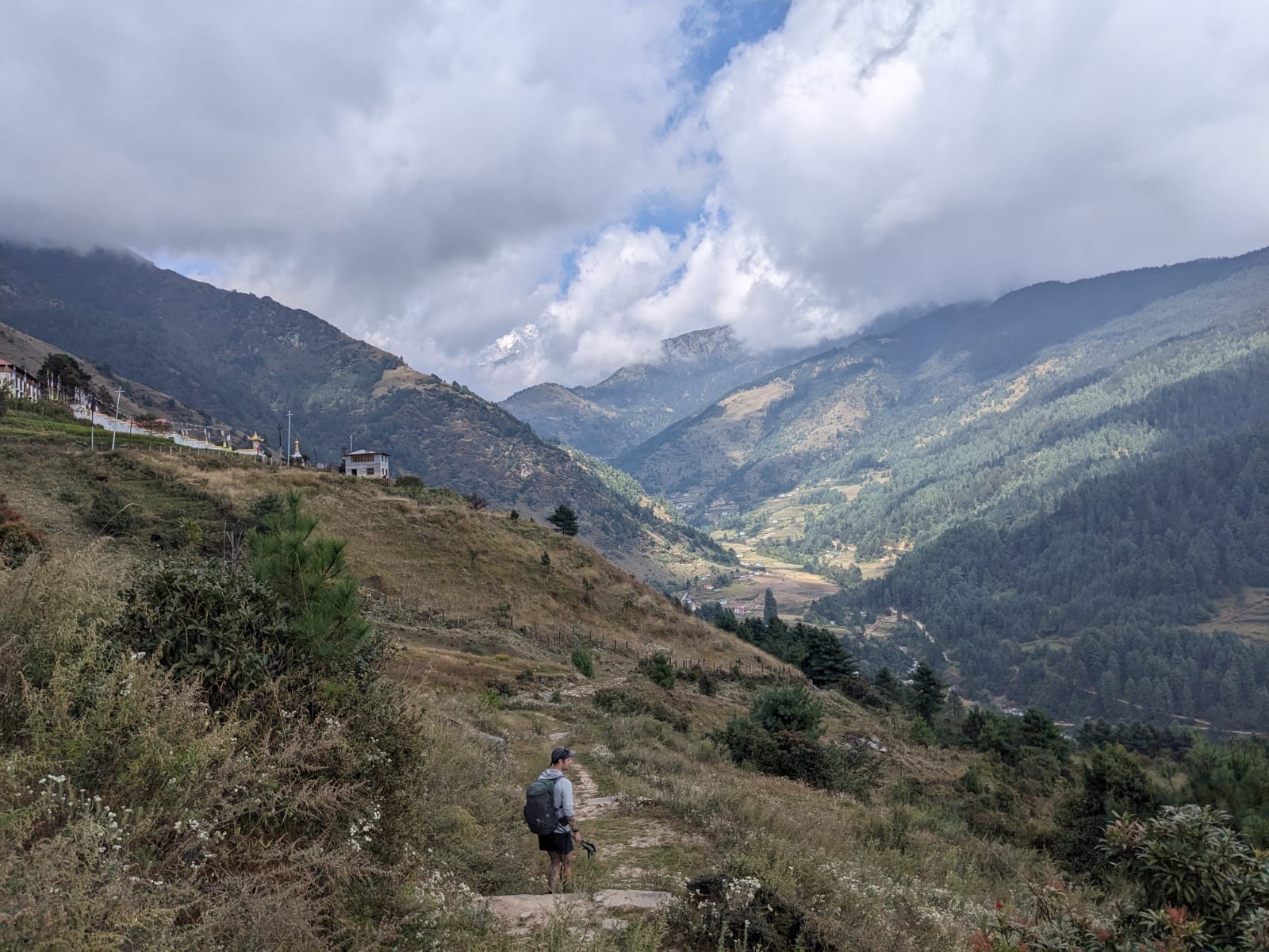
I enjoyed our first few days in the misty foothills, through picturesque villages like Bandar, Junbesi and Nunthala, but the lack of tourist traffic was evident all around. In some places, there seemed to be more teahouses than hikers, and many have shut their doors permanently. I first hiked here six years ago, and nondescript sections of the route would trigger little memories, as if they'd been physically discarded at the side of the trail, waiting to be retrieved. We bumped into a few more hikers as we got closer to Lukla, largely people who had been forced into taking long jeep rides because the cloudy weather had delayed their flights. I'm normally fairly sanguine about the new roads, but once we passed Bupsa and started walking along the muddy jeep track, I felt a pang of sadness as I looked down on sections of the old forest trail buried under rubble ten metres or so below us. I know that this is not my country, and these are not my trails to mourn. I also know that I have the privilege of being relatively young and able-bodied, and that I come from a society that has, for better and worse, already been shaped around the imperatives of the car. None the less, I maintain that there is something precious about places which can only be reached on foot. At a teahouse in Puiya, which the road reached this spring, I asked the owner what she thought about the construction. She made a 'so-so' gesture with her hand, “soon, people won't stop here anymore”.
Make no mistake, to hike in the Everest region is to experience some of the most sublime mountains on earth. It's also to hike on one of the most commercialised routes in the world, and once you pass Lukla, the whole trail is geared around the tourist economy. Every hour or so you pass small clusters of teahouses, cafes, bakeries, and shops selling everything a hiker might have forgotten. We had now joined the main Everest Base Camp trail, and the quiet of the first few days was replaced by huge throngs of hiking groups with their armies of porters and guides, as well as long yak and mule caravans carrying gas cylinders, sacks of rice, and all the other supplies needed to feed thousands of hikers. I'd never witnessed the trail in peak autumn hiking season before, and it was clear that the lure of the world's highest mountain was as strong as ever.
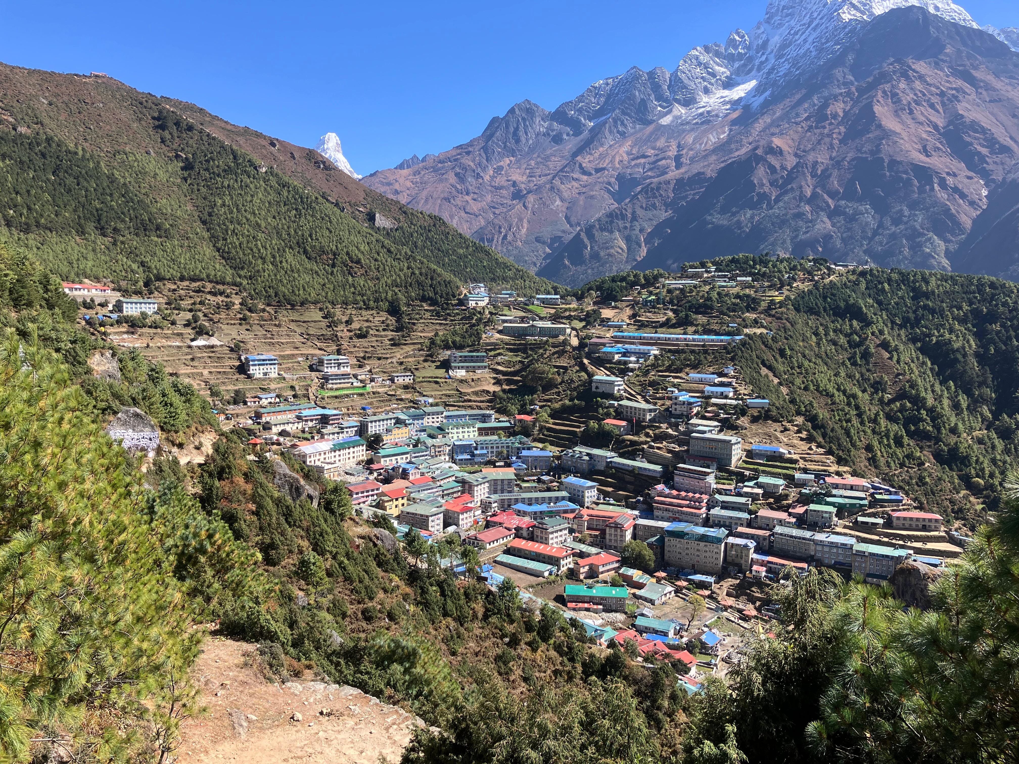
The gateway to the Everest region is Namche Bazaar, a whole town sat improbably on the hillside, now swelling with dozens of hotels, with more under construction. It's about a day's walk past Lukla, and it marks the end of the foothills and the beginning of the high mountains. Before it was a tourist town, as the name suggests, it was a marketplace for the local valleys and further beyond. This part of the Himalayas has been occupied for about 600 years, when the Sherpa people migrated from neighbouring Tibet, probably by crossing the Nangpa La (5806m), a pass which sits 20 or so miles to the north of Namche. It's one of very few places where you can cross the Great Himalayan range here, as most of the Khumbu is bordered by a wall of high, impassable mountains. The pass was still in use as a trading route as recently as a couple of decades ago, and Tibetan herders would regularly bring yak caravans into Namche for market day. China closed the border crossing permanently after the infamous 2006 incident where the Chinese military opened fire on a group of 75 Tibetans who were attempting to flee into Nepal, killing Kelsang Namtso, a 17 year-old nun (news of the incident may have never reached the outside world, if it wasn't for a group of climbers on Cho Oyu who witnessed the shooting, and captured photographic evidence). Namche still hosts a weekly market, but the supplies now arrive solely from the south.
After a rest day which I spent enjoying the luxuries of hot showers and real coffee, now began the slow and serious business of acclimatisation. The next few days involved gradually ascending to Chukkung (4730m), the final stop before pushing over the first of the high passes. The trail leads first to Tengboche (3860m), the site of the famous monastery where Everest summiteers seek blessings and ask the mountain gods for safe passage; and then to Pangboche (3930m), where we stayed before an early morning hike to Ama Dablam Base Camp. As we arrived, a group of climbers were stood with binoculars watching a helicopter circle Camp 2, a precarious ledge at 6000m wide enough for only a couple of tents. There was an attempted rescue in progress of a frostbitten climber, and the only way was to reach him was to use a long line, where a rescuer is suspended 100 feet below the helicopter, and the casualty is strapped to them for evacuation. After four or so attempts at maneuvering the helicopter into position, they were finally successful, and we could just about make out the silhouette of two people dangling from the rope as the helicopter sped back down the valley towards Namche.
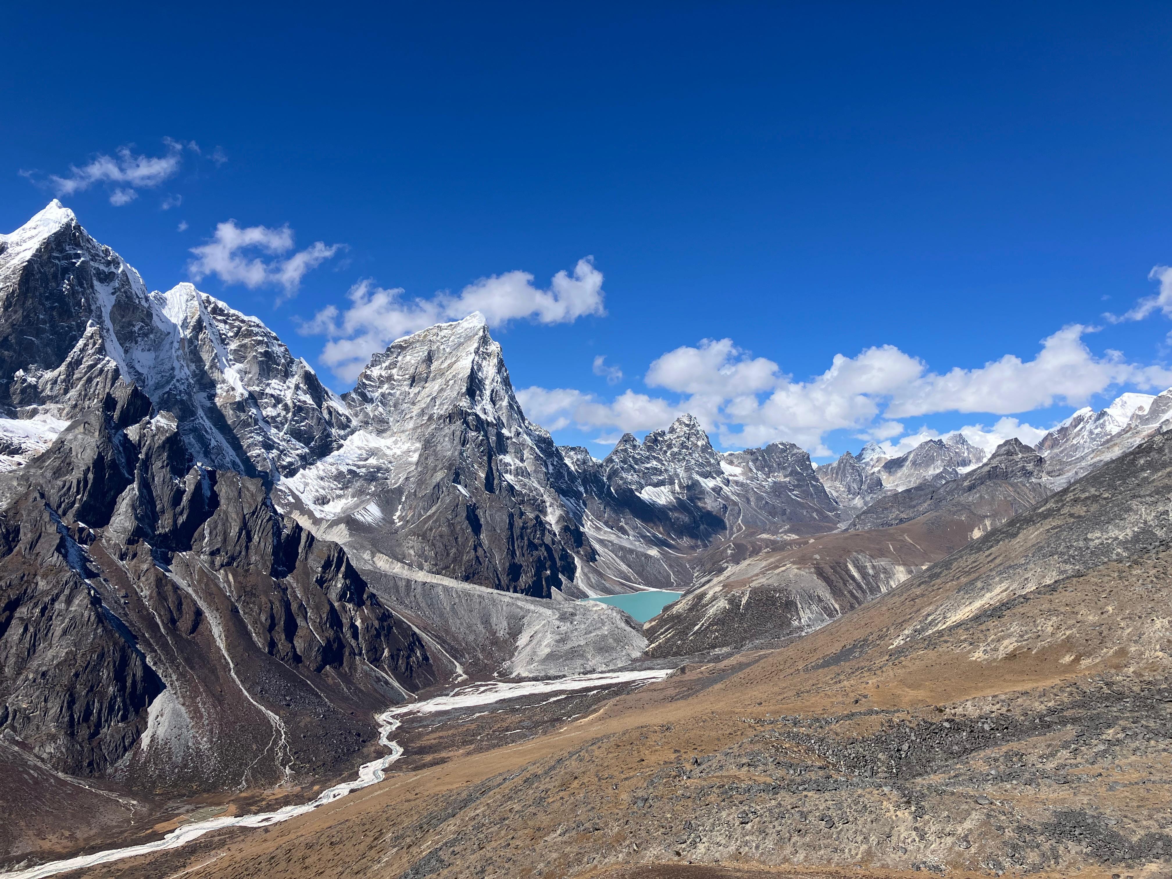
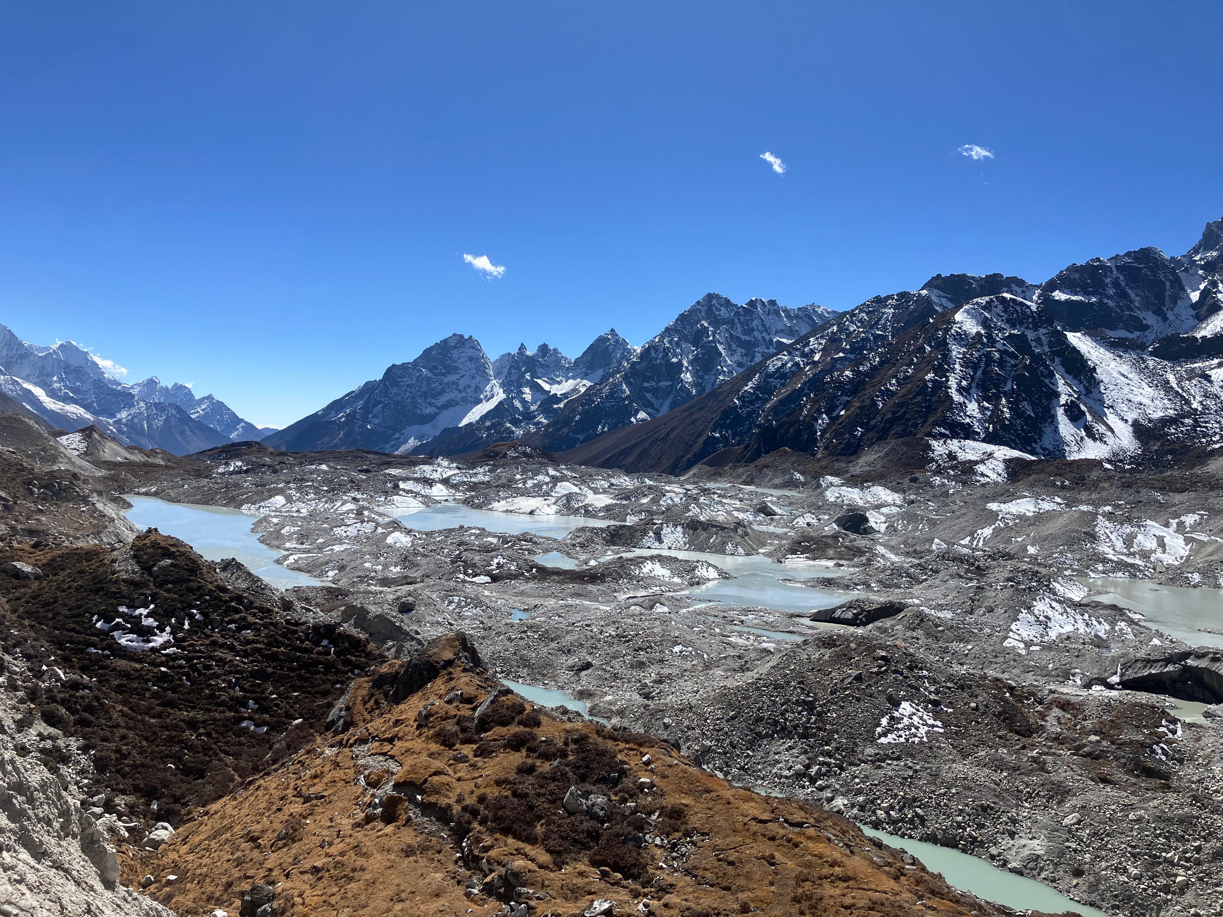
Once we passed the village of Dingboche (4410m), we once again left the main EBC highway and things got noticeably quieter. To be fair, anywhere in the Khumbu, it's not hard to find solitude once you leave the main trail. We spent a couple of days exploring the Imja Valley beyond Chukhung (4730m), a wild glacial moraine with stunning blue lakes, hemmed in by the south faces of Makalu, Lhotse and Nuptse. It's a place that feels like the end of the known world, as beyond those mountains lie the vast plains of Tibet, a land largely forbidden to outsiders.
As the name gives implies, the crux of this route is three, high passes: the Kongma La (5535m), Cho La (5420m), and Renjo La (5340m), which we planned to hike over three days. From Chukhung, the climb towards the Kongma La takes you across scree and grasslands above the village, before a steep, rocky climb to the pass. We moved at a good pace. For me, the months of high-altitude hiking were clearly paying off, and I can't recall ever feeling this strong above 5000m. Kevin kept up on pure fitness, and we reached the pass in under 3 hours, a good 90 minutes faster than I'd managed two years ago. The descent is slow and treacherous, down a steep boulder field still partly under snow, and then a tedious crossing of the debris-covered Khumbu glacier to reach the village of Lobuche (4940m), one of the main stops on the EBC trail. As we descended, we could see the lines of people entering and exiting the village, and hundreds more coming up the valley to join them.
We all react to crowds with a kind of solipsism – bemoaning the fact they're there, while struggling to accept that we are, quite literally, part of the crowd. The overcrowding on Mount Everest itself has been well documented, but ever rising visitor numbers to the surrounding valleys is also placing a huge burden on the local environment. Lobuche feels like it's creaking at the seams. While Kevin and I did our best to reduce our impact (for example, by purifying our drinking water instead of relying, as many hikers shamefully do, on dozens of plastic bottles), we were still here, eating, drinking, consuming. We had all unwittingly become 'last-chance' tourists, people who flock to fragile ecosystems to witness them before they are irrevocably transformed by the juggernaut of anthropogenic climate change. The Himalayas are sometimes referred to as the 'third pole', because they hold the largest reserves of ice outside of the polar regions, providing freshwater for vast populations of people in China and South Asia. And I, like most of my fellow hikers, had taken a long-haul flight to gaze upon the rapidly receding glaciers.
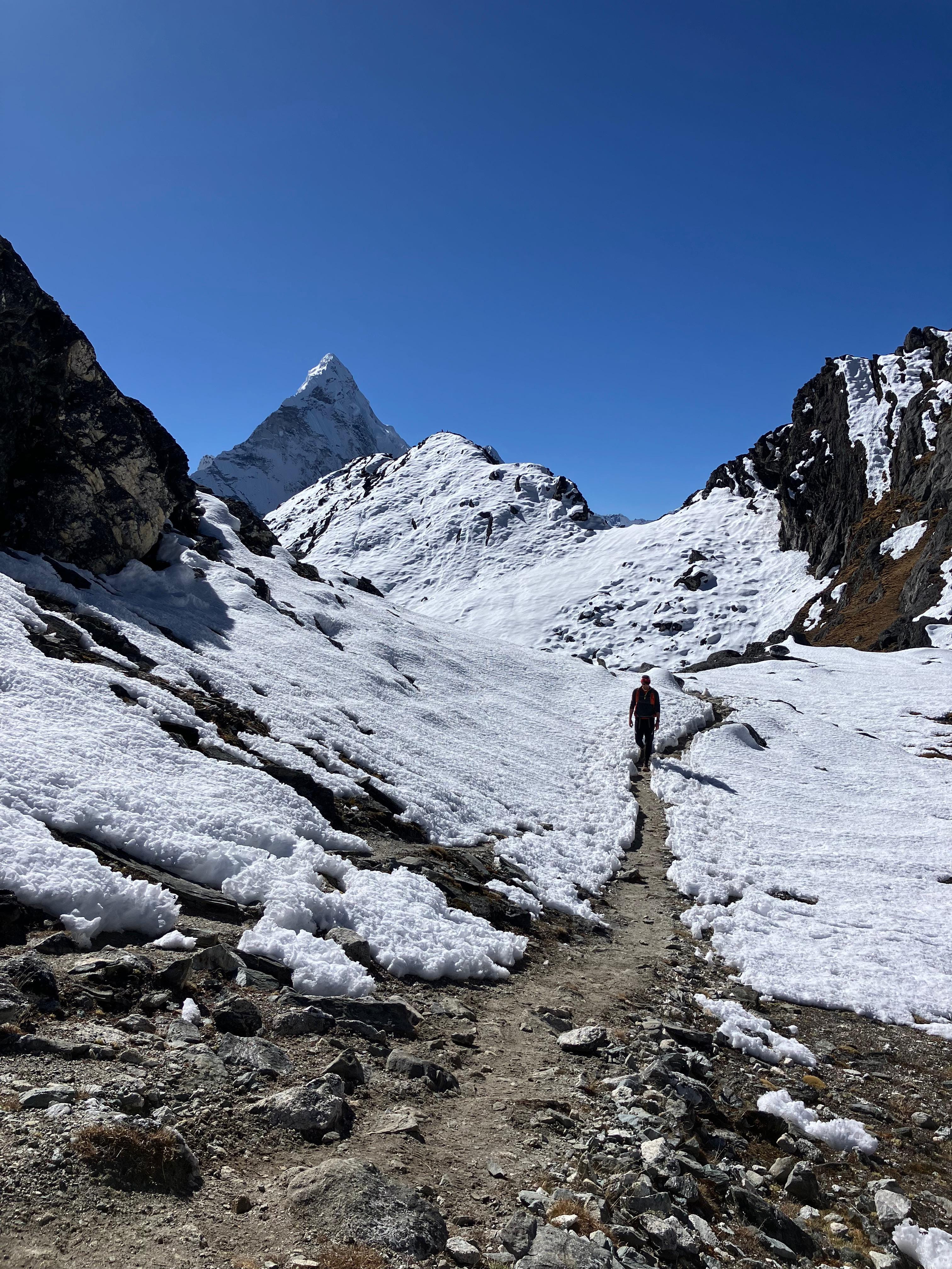
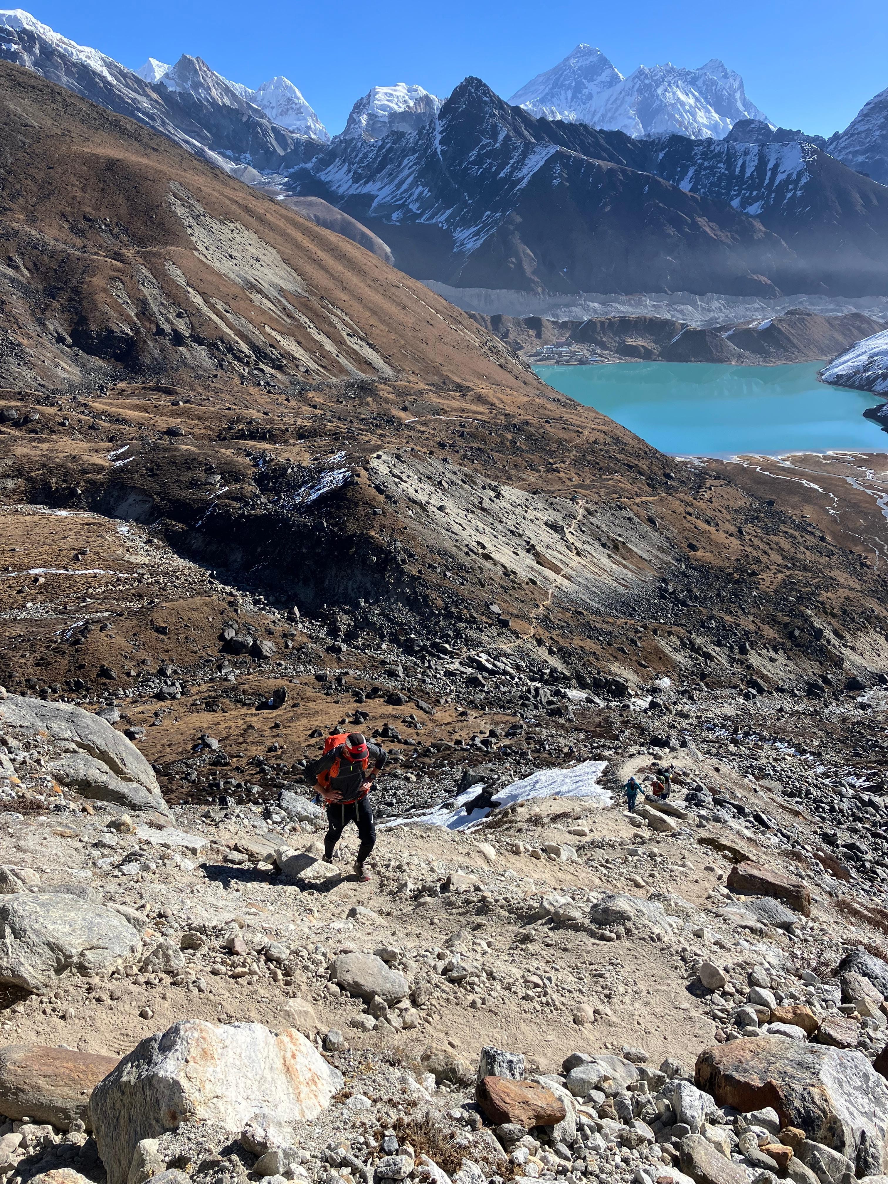
After a quick break, we were happy to escape Lobuche and we were soon back on empty trails, this time to Dzongla, a small hamlet that sits under the imposing north face of Cholatse. In the morning we left for the Cho La, the only glaciated pass, and one which elicits nervous mutterings from first-time hikers. In truth, it's straightforward enough, you just have to follow a series of metal stakes that local sherpas have installed to guide hikers safely across the glacier. After reaching the pass, there are cables to assist you down the steep scree descent, before a few gentle downhill miles following a mountain stream. The last stretch to Gokyo crosses another great moraine, an ever-changing lunar landscape where the sound of rockfall frequently breaks the silence, and finally the great blue lakes of Gokyo peer into view.
The next morning, we were both tired. We'd been sleeping above 4400m for over a week at this point, and the lack of good quality sleep was catching up with us. Time at altitude is always a balance between acclimatisation and fatigue, and as we trudged towards the Renjo La and the lakes of Gokyo gradually retreated into the distance, it was clear fatigue was winning.
From the pass, it's a long steady downhill to reach the comparatively thick air of Thame (3820m), another village in the Khumbu that's famous for producing mountaineers, and we stayed at the lodge of Apa Sherpa, the man who used to hold the record for the most Everest summits (twenty-two). He told us that after promising his wife that his 22nd summit would be his last, he's now happily retired (and his neighbour in Thame now holds the record). The next morning after a short couple of hours down the valley, we were back in Namche to rest for a day before hiking 60 or so kilometers out to the road head at Phaphlu, where we could catch a jeep back to Kathmandu and avoid taking a chance on the unreliable flights. We only had two days to do it if Kevin was going to make his flight home, and so we dug deep one last time and raced back down the trail, reaching Phaphlu in darkness to grab a few hours sleep before a long and tiring jeep ride back to the city.
Thank you Pete for sharing you experiences in such expressive words. It feels like I am there with you.
Great to read of Kevin and your adventures x